Arizona Official State Visitor’s Guide
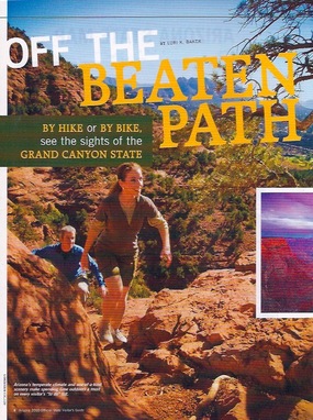
Off the Beaten Path
By hike or by bike, see the sights of the Grand Canyon State
No matter how many times I peer over the rim of the Grand Canyon, I always have the same reaction. I gasp, suddenly taken aback by this gorge of breathtaking proportions, carved out of rock by the Colorado River over a period of millions of years.
Once that initial shock of being just inches from a mile-long nosedive wears away, I smugly feel I can view the entire canyon from the rim: its vast cliffs, rock strata that take on ever-shifting colors with the changing light, buttes, temples and blue ribbon of river. In this vastness, a deep sense of tranquility washes over me as today’s worries (namely about heights) dissolve in the face of 6 million years of geological time.
But the Canyon—like Arizona’s mountain ranges, forests, deserts and rivers—beckons us to be more than life’s detached observers. Arizona’s great outdoors call us to become active participants in countless adventures along Arizona’s hiking and biking trails. Here’s a guide to some of the state’s most popular adventures by foot or bike pedal, beginning with the mother of all hiking landscapes, the Grand Canyon. It’s always best to check ahead for each park’s operating hours
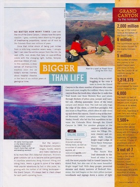
Bigger Than Life
The only thing as mind-boggling as the eons it took to form the Grand Canyon is the sheer number of tourists who come here each year: roughly 5 million. Many view the canyon from the South Rim, where the 12-mile Rim Trail heads east from Hermits Rest and winds through thickets of piñon pine, juniper and Gambel oak, offering panoramic views of the inner canyon and distant river. The trail not only hugs the edge of The Abyss, a 3,000-foot precipice, but also leads to Hopi Point, which offers 45-mile views up and down the canyon. There’s a stop at the Powell Memorial, which commemorates Major John Wesley Powell, who led the first expedition to traverse the Colorado River through the Grand Canyon in 1869. For another glimpse at the Canyon’s colorful past, enter the Village Historic District and explore the Kolb Studio, Bright Angel Lodge, El Tovar Hotel, Verkamp’s Visitor Center and Hopi House.
The South Rim Trail descends to the head of what is not only the most popular trail in Grand Canyon National Park, but also one of the most beautiful: Bright Angel Trail. With deep gorges, perennial streams and dusky narrows of Redwall limestone, the trail begins at the rim’s piñon-juniper woodlands and zigzags down a series of tight switchbacks called Jacob’s Ladder. Beyond the switchbacks, the trail opens up into the basin of Garden Creek, often hidden from view by thickets of willow and canyon wild grapes. Nevertheless the brown cliffs binding the narrows act as amplifiers for its musical gurgling waters. Beyond the creek, watch out for the Devil’s Corkscrew, actually just another series of switchbacks that lead you to the pencil-thin waterfall of Columbine Spring, which gushes from a canyon wall, giving life-sustaining water to a hanging garden of maidenhair fern, scarlet monkeyflower and golden columbine. Further down, Bright Angel hooks into the River Trail, branching east just before reaching the Colorado River, where weary hikers find respite at Bright Angel Campground and Phantom Ranch. For another adventurous South Rim hike, try the South Kaibab Trail, which also leads to Bright Angel Campground and provides an easier day hike to Cedar Ridge.
For a greater sense of remoteness and unspoiled grandeur, journey to the North Rim, which receives about a tenth the number of visitors as the South Rim (it is also closed during the winter months). Its most popular trail, the 14.2-mile North Kaibab Trail, includes popular day hikes, such as the 3.6-mile round trip that scrambles down Esplanade sandstone en route to the short Supai Tunnel. From here, hikers are rewarded with inner canyon views of red rock ledges and sun-drenched slopes dotted with cliffrose and Apache plume. Stronger hikers journey down the 10-mile round trip to Roaring Springs for a trek through a deep Redwall limestone canyon and past the spire known as The Needle to the green oasis formed by Roaring Springs, whose waters flow in terraced cascades down canyon walls. Beyond Roaring Springs, the trail descends down occasionally steep shale slopes and winds through Tapeats sandstone narrows before approaching Bright Angel Creek at the mouth of Manzanita Canyon. Along the way, hikers feel miniscule beneath soaring cliffs framing the conifer-fringed North Rim looming 4,000 feet above.
For a shorter, easier North Rim option, try the 1.5-mile Transept Trail, which skirts the North Rim and overlooks a side canyon called The Transept.
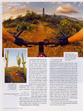
Arizona Trail
One of America’s newest and most scenic long distance trails, the Arizona Trail stretches from the Utah border on its northern fringe for 817 miles south to Mexico. Unlike America’s other long-distance trails that follow one mountain range, such as the Pacific Crest Trail or the Appalachian Trail, the Arizona Trail links a wide variety of southwestern vistas: winter’s snow-capped San Francisco Peaks, 21 miles rim-to-rim of the Grand Canyon, and the stark desert of Saguaro National Park near Tucson, to name a few. It crosses eight distinct mountain ranges, four national forests and 225 miles of the Sonoran Desert. It links Indian cliff dwellings and old mining camps to ghost towns and quaint communities like Patagonia.
With traces of previous civilizations still lingering behind, it’s also a walk through Arizona’s history, from prehistoric Native Americans to Spanish conquistadors and western frontiersmen. Beyond the lore of the Old West is the history of the trail, championed by fifth-grade Flagstaff teacher and hiking enthusiast Dale Shewalter, who became intrigued by the possibility of a Utah-to-Mexico hike after he moved to the state in 1974. He worked tirelessly to make it a reality, and 35 years later President Obama designated the Arizona Trail as a National Scenic Trail in March 2009.
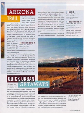
Quick Urban Getaways
Hikers and bicyclists never need to venture far outside the city limits of Phoenix, Flagstaff or Tucson to become immersed in nature. One of the most popular urban hikes in Arizona, rivaling only the Grand Canyon’s Bright Angel Trail in popularity, is the 1.2-mile-long jaunt up switchbacks to the 2,608-foot summit of Piestewa Peak in the Phoenix Mountain Preserves. The summit offers 360-degree views of a ring of peaks: Bradshaw Mountains, Pinnacle Peak, McDowell Mountains, the Superstition Mountains and South Mountain. It’s the perfect vantage point for a famed Arizona sunset awash in hues of azure, violet, pink and orange, with Phoenix’s city lights twinkling below like thousands of stars.
To the north, the Flagstaff Urban Trail System’s 49 miles of hiking and biking trails wend through Flagstaff’s historic and funky Route 66, stands of old-growth Ponderosa pine and native grasslands with panoramic views of the San Francisco Peaks. Don’t miss the 2-mile loop around Buffalo Park with open, native grasslands atop an ancient lava flow, wooded ravines and a picture-postcard view of the Peaks.
Just 15 miles (or 29 minutes) north of Tucson at the base of the Santa Catalina Mountains, Catalina State Park offers a quick nature fix on the mile-long Nature Trail, with interpretive signs explaining the desert ecosystem and its wildlife inhabitants. Longer options include the 7.2-mile Romero Canyon Trail and 10.5-mile Sutherland Trail, which cut a path through desert and riparian canyons with relaxing pit stops at cool, natural pools.
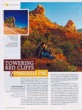
Towering Red Cliffs & Ponderosa Pine
Sedona’s clay-red sphinxlike formations—Bell Rock, Courthouse Butte, Capitol Butte and Cathedral Rock—beckon hikers and bikers to its exotic landscape dotted with piñon-juniper woodlands, Arizona cypress and tall, swaying desert grasses beneath cobalt blue skies. An easy entrée to its adventures lies in its arterial network of more than 100 miles of hiking and mountain biking trails that begin at Bell Rock Pathway, a 3.5-mile trek with wide paths and gently sloping red gravel that winds past Bell Rock and Courthouse Butte. Beyond here, hikers and more experienced mountain bikers can explore many other loops, including following the historic 15-mile Lime Kiln Trail to Dead Horse State Park. The trail allows visitors to experience a slice of Sedona’s early settlement history, back when the path was actually a wagon road linking the mining town of Jerome to the Oak Creek farming community of Sedona.
Southwest of Sedona outside of Prescott, a picture-postcard panorama awaits visitors on the two-mile hiking loop encircling Lynx Lake. Cumulus clouds drift lazily over the Bradshaw Mountain’s blue silhouette stretching across the horizon. Gentle breezes stir the 55-acre lake, where the sky’s reflection ripples into a kaleidoscope of stormy gray, cerulean blue and sunlight gold. Fishermen stand patiently on the shore, waiting for a tug on their lines from a rainbow trout, bluegill or bass. Bicyclists can enjoy the views along the 3.2-mile Ranch Trail, 4.3-mile Salida Gulch Trail or 7-mile Homestead Trail.
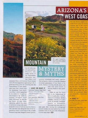
Mountain Mystery & Myths
Just 40 miles east of metropolitan Phoenix, the rocky spires of the Superstition Mountains lure day hikers and mountain bikers with Sonoran Desert beauty and a Western legend too captivating to die. A good launching point for venturing into the Superstitions is Lost Dutchman State Park, named after the mysterious “Lost Dutchman Mine,” which, legend has it, is a mine rich in gold ore discovered in the 1870s by the Prussian immigrant Jacob Waltz. Of course, no one else has found the gold mine, which just adds to the sense of adventure along trails such as Jacob’s Crosscut Trail, the easy, less-than-a-mile trail that runs along the base of the Superstitions before connecting to the 2.4-mile Treasure Loop Trail, fringed by desert grasses, scattered brittlebush and stately saguaros. The trail gently climbs to reveal changing mountain panoramas of Four Peaks to the north, Flatiron towering directly above and twin rock spires known as Praying Hands.
While no one struck gold in the Superstitions, in 1974 two spelunkers from the University of Arizona did find a hidden treasure nine miles south of Benson: Kartchner Caverns, an underground limestone cave now housed in a state park. After exploring the awe-inspiring underground natural wonder, you can explore the 4.2-mile Guindani Trail on the west side of Kartchner Caverns State Park.
Arizona’s West Coast
Not only did the mighty Colorado River sculpt the Grand Canyon, but it also forged Arizona’s west coast, spinning a green ribbon of lush cottonwood-willow forests, cattail wetlands and lagoons laced through arid desert mountains. Back in 1949 pioneer conservationist Aldo Leopold unveiled the beauty and splendor of this region in his “A Sand County Almanac.”
Dams have since shackled the once-mighty Colorado River, but its natural grandeur remains along hiking trails at Cattail Cove State Park and Buckskin Mountain State Park. Cattail Cove State Park’s Whytes Retreat Trail, a 1 ½-mile easy hike, follows Lake Havasu’s shimmering shoreline while overlooking the lower portion of the Colorado River and Parker Dam. For another glimpse of the river known as the “American Nile,” trek along Buckskin Mountain State Park’s Lightning Bolt Trail, a 3-mile loop that heads into the Buckskin Mountains and commands views of cottonwood-willow stands, reed and cattail lining the river. Overhead, osprey, merlin and brown and white pelican skim the sky, while an occasional white egret stands like a statue near the shore.
Grand Canyon by the Numbers
2,000 million—the age of the oldest rocks at the bottom of the Grand Canyon
6 million—the approximate age of the Canyon, incised by the mighty Colorado River
5 million—the number of visitors who journey to the Grand Canyon each year (most of them view the Canyon at car overlooks along the South Rim)
1,218,375—the number of acres encompassed by Grand Canyon National Park
6,000 feet—the depth of the Grand Canyon at its deepest point. It spans 15 miles at its widest, and its length is 277 river miles, beginning at Lees Ferry and ending at Grand Wash Cliffs.
More than 1,500—the number of plant species that can be found in the canyon, along with 355 types of birds, 89 different mammals, 47 species of reptiles, 9 types of amphibians and 17 different fish species.
Five out of seven—the number of life zones in the Grand Canyon (Lower Sonoran, Upper Sonoran, Transition, Canadian and Hudsonian). This is the equivalent of driving from Mexico to Canada.